Click to visit the main New York Public Library Homepage
The New York Public Library
Digital Collections
About Digital Collections
Browse
Search only public domain materials
Items
Collections
Divisions
Home
Search
Browse
About
Search only public domain materials
Items
Collections
Divisions
Digital Collections
Using Images
Using Data
Search
Filtered search
Show filters
Hide filters
Show Only Public Domain
topic
Real property
8500
Fire insurance
5103
Cities & towns
4998
Maps
361
Railroads
274
More
Less
name
Sanborn Map Company
5093
G.W. Bromley & Co
2391
Bromley, George Washington
797
Bromley, Walter Scott
797
Austro-Hungarian Monarchy. Militärgeographisches Institut
763
More
Less
collection
Atlases of New York City
9621
Atlases of the United States
1621
Maps of New York City and State
847
Spezialkarte der Osterreichisch-Ungarischen Monarchie
763
Maps of North America
702
More
Less
place
New York (State)
9290
New York
3095
Manhattan (New York, N.Y.)
1853
New York (N.Y.)
1740
Brooklyn (New York, N.Y.)
733
More
Less
genre
Maps
13974
Atlases
1607
Topographic maps
977
Cadastral maps
197
Plans
111
More
Less
publisher
Sanborn Map Company
5129
G.W. Bromley & Co
2294
E. Belcher Hyde
780
K.u.K. Militargeographisches Institut
763
E. Robinson Co
249
More
Less
division
Map Division
13622
General Research Division
184
Manuscripts and Archives Division
82
Schomburg Jean Blackwell Hutson Research and Reference Division
71
George Arents Collection
51
More
Less
type
x
cartographic
text
281
still image
121
Date Range
to
14,082 results found
Filtering on:
x
Date
: 1887 - 1975
x
Type
: cartographic
Sort by:
Title
Date created
Date digitized
Sequence
Results 751 - 800
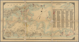
Nell's topographical map of t…
m
Map of the Denver & Rio Grand…
Proposed lines of Mission sta…
Zones of Mohammedan and Chris…
Johannesburg―the Hub of South…
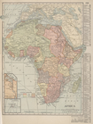
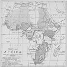
Africa
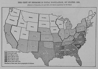
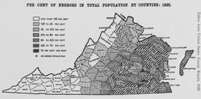
Per cent of Negroes in total …
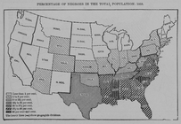
Percentage of Negroes in the …
Slave trade map of equatorial…
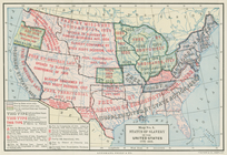
Status of slavery in the Unit…
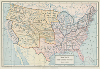
The United States, March 4, 1…
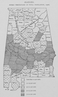
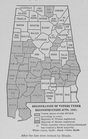
Alabama. Negro percentage of …
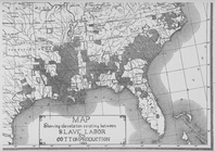
Map showing the relation exis…
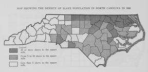
Map showing the density of sl…
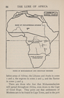
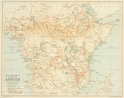
Treaty map of Africa
Large scale sectional map of …
m
Geology of Ohio, vol. VII, Ma…
1899 Railroad map of Ohio
Railroad map of Ohio
Climatic map of California
Montana Fort Logan sheet
Montana Helena sheet
Montana, Helena special map
m
Rand, McNally & Co.'s new bus…
m
Ide's map of Montana
Map of the state of Montana
Traver's map of Tacoma and en…
City of Spokane Falls, Washin…
Spokane Falls : showing in re…
Whitney's map of Seattle and …
C.H. Amerine's sectional map …
Map of the country adjacent t…
m
Vicinity map, Duwamish River …
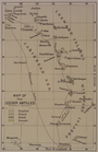
Map of the Lesser Antilles
Topographic sheet, Montana (S…
Boston with its environs
m
Map of Long Island: based upo…
m
Map of Long Island: based upo…
A geological and topographica…
Maryland - District of Columb…
Geological map of Indiana : s…
m
Rand McNally and Co's standar…
Per cent of negroes in total …
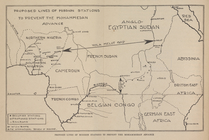
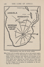
Map of Africa
Registration of voters under …
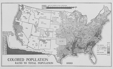
Colored population ratio to t…
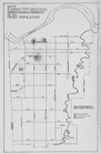
Map of Kansas City, Missouri;…
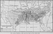
The cotton kingdom, 1850, and…
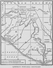
Liberia's portable boundary
Territory of Arizona
1
2
3
4
5
6
7
8
9
10
…
56
57
Previous
Next
1
2
3
4
5
6
7
8
9
10
…
56
57
Previous
Next