Click to visit the main New York Public Library Homepage
The New York Public Library
Digital Collections
About Digital Collections
Browse
Search only public domain materials
Items
Collections
Divisions
Home
Search
Browse
About
Search only public domain materials
Items
Collections
Divisions
Digital Collections
Using Images
Using Data
Search
Filtered search
Show filters
Hide filters
Show Only Public Domain
topic
Real property
8500
Fire insurance
5103
Cities & towns
4998
Maps
361
Railroads
274
More
Less
name
Sanborn Map Company
5093
G.W. Bromley & Co
2391
Bromley, George Washington
797
Bromley, Walter Scott
797
Austro-Hungarian Monarchy. Militärgeographisches Institut
763
More
Less
collection
Atlases of New York City
9621
Atlases of the United States
1621
Maps of New York City and State
847
Spezialkarte der Osterreichisch-Ungarischen Monarchie
763
Maps of North America
702
More
Less
place
New York (State)
9290
New York
3095
Manhattan (New York, N.Y.)
1853
New York (N.Y.)
1740
Brooklyn (New York, N.Y.)
733
More
Less
genre
Maps
13974
Atlases
1607
Topographic maps
977
Cadastral maps
197
Plans
111
More
Less
publisher
Sanborn Map Company
5129
G.W. Bromley & Co
2294
E. Belcher Hyde
780
K.u.K. Militargeographisches Institut
763
E. Robinson Co
249
More
Less
division
Map Division
13622
General Research Division
184
Manuscripts and Archives Division
82
Schomburg Jean Blackwell Hutson Research and Reference Division
71
George Arents Collection
51
More
Less
type
x
cartographic
text
281
still image
121
Date Range
to
14,082 results found
Filtering on:
x
Date
: 1887 - 1975
x
Type
: cartographic
Sort by:
Title
Date created
Date digitized
Sequence
Results 1001 - 1050
1892 Tallapoosa, Ga., Haralso…
Plat of the city of Tallapoos…
Plan of the town Ebenezer and…
Map of the business and centr…
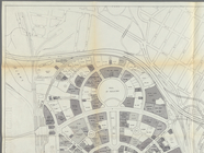
Chicago Tribune's Columbian S…
Map showing territorial growt…
m
Rand, McNally & Co.'s new ind…
Map of the buildings and grou…
Map of Indiana
Indiana, 1820
Indiana
Railroad Commissioners' map o…
A compleat map of North-Carol…
Map of North Carolina and Sou…
Map of Western North Carolina…
New Castle, Virginia, Series …
Quincy in 1888 : supplement t…
Ottawa, Illinois, 1898 : situ…
Map of South Waukegan showing…
m
Map of Roanoke, Virginia : sh…
Illinois
Arbachoochee, Alabama : Dense…
Map of the Cahaba coal field …
m
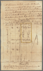
Tivoli calculation for Peter …
m
Colonel De Lancey's cleared l…
m
Totten and Crossfield's divis…
m
The late John Quackenboss's e…
m
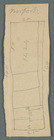
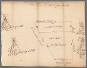
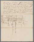
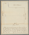
Bowery Lane
m
Stone Street and Broad Street
m
Lot in Princess Street
m
Pearl Street
m
Rear part of lot 1424 Norfolk…
m
B. Peck heirs at Water and Fr…
m
Water and Front Streets, Peck…
m
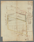
Greenwich, Washington, Robert…
m
Map of the business district …
m
Confidential Space Allocation…
m
Map of the Clutter farm in Ca…
m
Hague Street and Queen Street
m
Fitz Roy or Greenwich and Abi…
m
Norfolk, Suffolk, Division, a…
m
Broome Street near Crosby Str…
m
Coenradt Ten Eyck's lot west …
m
John Jay's ground corner Broa…
Map of the Cumberland coal re…
m
Map of James River, Virginia …
Map of the taxing district of…
Map of the vicinity of Richmo…
Railroad map of Illinois, 189…
Railroad map of Illinois, 189…
1
2
3
4
5
6
7
8
9
10
…
56
57
Previous
Next
1
2
3
4
5
6
7
8
9
10
…
56
57
Previous
Next