Click to visit the main New York Public Library Homepage
The New York Public Library
Digital Collections
About Digital Collections
Browse
Search only public domain materials
Items
Collections
Divisions
Home
Search
Browse
About
Search only public domain materials
Items
Collections
Divisions
Digital Collections
Using Images
Using Data
Search
Filtered keyword search
Show filters
Hide filters
Show Only Public Domain
topic
Real property
10812
Fire insurance
5289
Cities & towns
5001
Administrative and political divisions
906
Railroads
784
More
Less
name
Sanborn Map Company
5093
G.W. Bromley & Co
2471
Bromley, George Washington
797
Bromley, Walter Scott
797
Austro-Hungarian Monarchy. Militärgeographisches Institut
773
More
Less
collection
Atlases of New York City
10577
Atlases of the United States
3749
Maps of North America
3345
Maps of New York City and State
2046
Lawrence H. Slaughter Collection of English maps, charts, globes, books and atlases
1101
More
Less
place
New York (State)
12153
New York
3978
New York (N.Y.)
2423
Manhattan (New York, N.Y.)
2371
Brooklyn (New York, N.Y.)
1166
More
Less
genre
Maps
24593
Atlases
3679
Topographic maps
1062
Surveys
1032
land surveys
849
More
Less
publisher
Sanborn Map Company
5129
G.W. Bromley & Co
2294
E. Belcher Hyde
780
K.u.K. Militargeographisches Institut
773
publisher not identified
452
More
Less
division
Map Division
22270
Manuscripts and Archives Division
1079
General Research Division
400
Rare Book Division
320
Schomburg Jean Blackwell Hutson Research and Reference Division
191
More
Less
type
x
cartographic
text
647
still image
322
Date Range
to
Looking for one of these collections?
Atlases of New York City
11,722 items
Atlases of the United States
3,868 items
Maps of North America
3,345 items
Maps of New York City and State
2,059 items
Lawrence H. Slaughter Collection of English maps, charts, globes, books and atlases
1,252 items
Bancker plans
1,080 items
24,808 results found for:
x
New York Maps
Filtering on:
x
Type
: cartographic
Sort by:
Relevance
Title
Date created
Date digitized
Sequence
Results 24751 - 24800
… of Brooklyn, City of
New
York
use:
… partner (e.g.,
New
York
Williams'
map
of Borough of Brooklyn …
use:
… partner (e.g.,
New
York
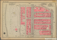
Bounded by Cathedral Parkway,…
use:
… partner (e.g.,
New
York
…, and the
New
Jersey shore
use:
… partner (e.g.,
New
York
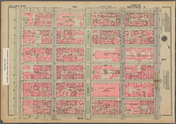
Bounded by W. 89th Street, Am…
use:
… partner (e.g.,
New
York
m
Street guide of Manhattan and…
use:
… partner (e.g.,
New
York
Bounded by W. 26th Street, Ni…
use:
… partner (e.g.,
New
York
Bounded by E. 71st Street, Th…
use:
… partner (e.g.,
New
York
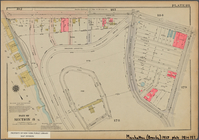
Bounded by Tiemann Place, W. …
use:
… partner (e.g.,
New
York
Bounded by Dyckman Street, Sh…
use:
… partner (e.g.,
New
York
m
…
map
use:
… partner (e.g.,
New
York
m
Map
of the City of
New
York
and its
use:
… partner (e.g.,
New
York
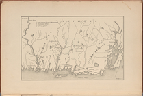
[Pequot War battle sites], fr…
use:
… partner (e.g.,
New
York
Bounded by W. 47th Street, Br…
use:
… partner (e.g.,
New
York
… of Queens, City of
New
York
use:
… partner (e.g.,
New
York
Railroad suburbs between Holl…
use:
… partner (e.g.,
New
York
m
King's birds-eye view of Broo…
use:
… partner (e.g.,
New
York
… of Queens,
New
York
City …
use:
… partner (e.g.,
New
York
Bounded by E. 20th Street, Av…
use:
… partner (e.g.,
New
York
The Cord Meyer Development Co.
map
showing
use:
… partner (e.g.,
New
York
Bounded by W. 178th Street, (…
use:
… partner (e.g.,
New
York
Bounded by W. 20th Street, Se…
use:
… partner (e.g.,
New
York
… of Queens,
New
York
City
use:
… partner (e.g.,
New
York
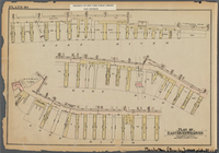
Plan of East River Wharves, P…
use:
… partner (e.g.,
New
York
m
Map
of the borough of Brooklyn,
New
York
…
use:
… partner (e.g.,
New
York
The Solar System
use:
… partner (e.g.,
New
York
Map
of Bellaire Estates …
use:
… partner (e.g.,
New
York
Greater
New
York
and contigous territory, showing
use:
… partner (e.g.,
New
York
… of Queens,
New
York
City
use:
… partner (e.g.,
New
York
m
Flushing Bay, Long Island, N.…
use:
… partner (e.g.,
New
York
Werpoes, a village of the Man…
use:
… partner (e.g.,
New
York
Histoire de la catographie de…
use:
… partner (e.g.,
New
York
Bounded by Avenue A, E. 91st …
use:
… partner (e.g.,
New
York
Yorkville and East Harlem in …
use:
… partner (e.g.,
New
York
m
Borough of Brooklyn, 5th cong…
use:
… partner (e.g.,
New
York
Grund-Plan der Judengasse im …
use:
… partner (e.g.,
New
York
Map
of borough of Queens
use:
… partner (e.g.,
New
York
Southern part of the borough …
use:
… partner (e.g.,
New
York
Alexandria Municipality, 8th …
use:
… partner (e.g.,
New
York
Bounded by W. 14th Street, Ni…
use:
… partner (e.g.,
New
York
…, with a part of East
New
York
use:
… partner (e.g.,
New
York
Bounded by W. 214th Street, (…
use:
… partner (e.g.,
New
York
…
Map
of Volume Two, Atlas of
New
York
City
use:
… partner (e.g.,
New
York
A
map
exhibiting the dark shadow of the moon
use:
… partner (e.g.,
New
York
The northwesterly part of the…
use:
… partner (e.g.,
New
York
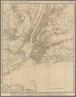
New
-
York
City, County, and vicinity …
use:
… partner (e.g.,
New
York
m
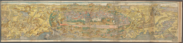
View of Jerusalem
use:
… partner (e.g.,
New
York
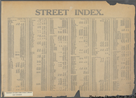
Street Index: [Abington Squar…
use:
… partner (e.g.,
New
York
…, with Pelham Manor, and
New
use:
… partner (e.g.,
New
York
Bounded by Nichols Place, Pay…
use:
… partner (e.g.,
New
York
1
2
…
91
92
93
94
95
96
97
98
99
100
Previous
Next
1
2
…
91
92
93
94
95
96
97
98
99
100
Previous
Next