Click to visit the main New York Public Library Homepage
The New York Public Library
Digital Collections
About Digital Collections
Browse
Search only public domain materials
Items
Collections
Divisions
Home
Search
Browse
About
Search only public domain materials
Items
Collections
Divisions
Digital Collections
Using Images
Using Data
Search
Keyword search
Show filters
Hide filters
Show Only Public Domain
topic
Real property
486
Administrative and political divisions
245
Railroads
238
Landowners
128
History
87
More
Less
name
E. Belcher Hyde Map Company
265
E.B. Hyde & Co
265
Ullitz, Hugo
265
United States. Farm Security Administration
89
New York (N.Y.). Board of Estimate and Apportionment
81
More
Less
collection
Maps of North America
725
Maps of New York City and State
564
Atlases of New York City
454
Farm Security Administration Photographs
88
Atlases of the United States
87
More
Less
place
New York (State)
868
New York
563
New York (N.Y.)
390
Brooklyn (New York, N.Y.)
372
Maps
344
More
Less
genre
Maps
1960
Photographs
146
Cadastral maps
121
Prints
120
Atlases
85
More
Less
publisher
E. Belcher Hyde
269
publisher not identified
90
New York (N.Y.). Board of Estimate and Apportionment
38
M.B. Brown Printing & Binding Co.,
37
New York (N.Y.). Dept. of City Planning
37
More
Less
division
Map Division
1964
Wallach Division: Photography Collection
107
Wallach Division: Picture Collection
41
General Research Division
40
Billy Rose Theatre Division
35
More
Less
type
cartographic
1962
still image
384
text
89
moving image
7
sound recording
6
More
Less
Date Range
to
2,373 results found for:
Scales
Sort by:
Relevance
Title
Date created
Date digitized
Sequence
Results 501 - 550
Map of the territory of Minne…
note:
Scale
not given (W 98°55ʹ--W 88°14ʹ/N 50°10
Map of the territory of Minne…
note:
Scale
approximately 1:1,250,000 (W 100°30ʹ--W
Map of the general government…
note:
Scale
1:760,320. 12 miles to one inch (W
Our centennial--plan of the g…
note:
Scale
not given (W 75°13ʹ40ʺ--W 75°11ʹ53ʺ/N
Plat of a survey of land "for…
note:
Scale
approximately 1:2,500 (W 84°21ʹ/N 46°30ʹ).
m
Missouri
note:
Scale
approximately 1:2,530,000 (W 95°46ʹ--W 89°06
m
Chicago
note:
Scale
1:6,000. 500 ft. = 1 inch (W 87°56
Chicago : correctly copied fr…
note:
Scale
1:7,200. 600 feet to an inch (W
New and enlarged map of Balti…
note:
Scale
approximately 1:14,076; 1173 feet
Revised design for the improv…
note:
Scale
not given (W 76°37ʹ31ʺ--W 76°35ʹ50ʺ/N
Map showing the boulevards an…
note:
Scale
approximately 1:33,000 (W 87°56ʹ24ʺ--W
New and enlarged map of Balti…
note:
Scale
approximately 1:14,076; 1173 feet
Map of Chicago and its wester…
note:
Scale
approximately 1:24,000 (W 87°56ʹ24ʺ--W
Chicago harbor
note:
Scale
: 1:1,200. 100 feet to 1 inch (W 87°37
Subdivision of Block 5 of the…
note:
Scale
not given (W 87°37ʹ--W 87°37ʹ/N 41°54
Map of Jackson Park : showing…
note:
Scale
approximately 1:4,800 (W 87°36ʹ25ʺ--W
Chicago
note:
Scale
not given (W 87°56ʹ24ʺ--W 87°31ʹ25ʺ/N
The city of Chicago, Cook Co.…
note:
Scale
approximately 1:20,000 (W 87°42ʹ--W 87°34
Map of Chicago showing water …
note:
Scale
approximately 1:64,000 (W 87°56ʹ24ʺ--W
Transportation lines tributar…
note:
Scale
not given (W 88°29ʹ--W 82°48ʹ/N 42°24
Map of the Indiana North and …
note:
Scale
not given (W 92°01ʹ00ʺ--W 78°48ʹ00ʺ/N
State of Indiana
note:
Scale
1:633,600. 10 miles to 1 inch. (W
Johnson's Indiana
note:
Scale
approximately 1:844,800 (W 88°--W 84°/N 42
A sketch of the public survey…
note:
Scale
1:1,140,480. 18 miles to an inch
Map of Chicago : showing the …
note:
Scale
1:56,320. 1 1/8 inches to a mile
City of Baltimore
note:
Scale
not given (W 76°36ʹ38ʺ--W 76°36ʹ38ʺ/N
Map of Texas and the countrie…
note:
Scale
approximately 1:4,500,000 (W 126°--W 86°/N
Bird's eye view of Philadelph…
note:
Not drawn to
scale
(W 75°13ʹ14ʺ--W 75°07
Map of the territories of Mic…
note:
Scale
1:1,900,800. 30 geographical miles
Hunt's map of Philadelphia : …
note:
Scale
approximately 1:23,000 (W 75°13ʹ45ʺ--W
Map of the city of Detroit, 1…
note:
Scale
approximately 1:14,500 (W 83°17ʹ16ʺ--W
m
To the honourable House of Re…
note:
Scale
1:19,800. 100 perches to an inch (W
This plan of the city of Phil…
note:
Scale
approximately 1:8,000. Not "600 feet
Map of the survey of Wissahic…
note:
Scale
1:9,600. 800 ft. to an inch (W
Map of part of Marquette Coun…
note:
Scale
not given (W 87°54ʹ--W 87°20ʹ/N 46°35
Geological map of the distric…
note:
Scale
approximately 1:168,960 (W 88°30ʹ--W 87°12
Sketch of the public surveys …
note:
Scale
1:1,140,480. 18 miles to an inch
m
Map of Michigan & part of Wis…
note:
Scale
approximately 1:633,600 (W 92°26ʹ--W 82°24
A.R. Roessler's latest map of…
note:
Scale
approximately
m
Revised map of the state of T…
note:
Scale
approximately 1:2,600,000 (W 105°17ʹ--W
To the citizens of Philadelph…
note:
Scale
approximately 1:28,000 (W 75°12ʹ42ʺ--W
Sketch I, showing the progres…
note:
Scale
1:600,000 (W
m
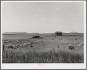
Abandoned tenant house and large-
scale
m
Map of Bates County, Missouri
note:
Scale
1:42,240. 1 3/4 inches to the mile
m
Map of Johnson County, Missou…
note:
Scale
1:42,240. 1 3/4 inches to the mile
m
Map of Pettis County, Missour…
note:
Scale
1:31,680. 2 inches to the mile (W
m
Colton's new sectional map of…
note:
Scale
1:633,600. 10 miles to an inch (W
m
Wright's map of Kansas City, …
note:
Scale
not given (W 94°34ʹ43ʺ/N 39°05ʹ59ʺ).
m
Map of the city of St. Louis,…
note:
Scale
not given (W 90°19ʹ13ʺ--W 90°09ʹ59ʺ/N
m
Post route map of the state o…
note:
Scale
approximately 1:953,400 (W 107°58ʹ--W
1
2
3
4
5
6
7
8
9
10
Previous
Next
1
2
3
4
5
6
7
8
9
10
Previous
Next