Click to visit the main New York Public Library Homepage
The New York Public Library
Digital Collections
About Digital Collections
Browse
Search only public domain materials
Items
Collections
Divisions
Home
Search
Browse
About
Search only public domain materials
Items
Collections
Divisions
Digital Collections
Using Images
Using Data
Search
Keyword search
Show filters
Hide filters
Show Only Public Domain
topic
Real property
486
Administrative and political divisions
245
Railroads
238
Landowners
128
History
87
More
Less
name
E. Belcher Hyde Map Company
265
E.B. Hyde & Co
265
Ullitz, Hugo
265
United States. Farm Security Administration
89
New York (N.Y.). Board of Estimate and Apportionment
81
More
Less
collection
Maps of North America
725
Maps of New York City and State
564
Atlases of New York City
454
Farm Security Administration Photographs
88
Atlases of the United States
87
More
Less
place
New York (State)
868
New York
563
New York (N.Y.)
390
Brooklyn (New York, N.Y.)
372
Maps
344
More
Less
genre
Maps
1960
Photographs
146
Cadastral maps
121
Prints
120
Atlases
85
More
Less
publisher
E. Belcher Hyde
269
publisher not identified
90
New York (N.Y.). Board of Estimate and Apportionment
38
M.B. Brown Printing & Binding Co.,
37
New York (N.Y.). Dept. of City Planning
37
More
Less
division
Map Division
1964
Wallach Division: Photography Collection
107
Wallach Division: Picture Collection
41
General Research Division
40
Billy Rose Theatre Division
35
More
Less
type
cartographic
1962
still image
384
text
89
moving image
7
sound recording
6
More
Less
Date Range
to
2,373 results found for:
Scales
Sort by:
Relevance
Title
Date created
Date digitized
Sequence
Results 751 - 800
m
Copy of section of photograph…
note:
Scale
1:80,000 (W 77°34ʹ44ʺ--W 77°19ʹ20ʺ/N
J.L. Hill Printing Co.'s map …
note:
Scale
: [1:18,000]. 1500 ft. = 1 inch (W
Mobile, 1888
note:
Scale
1:14,400. 1200 feet to the inch
Norfolk harbor, Virginia : fr…
note:
Scale
1:10,000 (W 76°19ʹ00ʺ--W 76°16ʹ30ʺ/N
Map shewing the position of t…
note:
Scale
approximately 1:17,000 (W 77°25ʹ59ʺ--W
Map of Richmond, Va. : and su…
note:
Scale
approximately 1:70,000 (W 77°36ʹ--W 77°12
Topographical map of lands be…
note:
Scale
approximately 1:20,000 (W 88°22ʹ31ʺ--W
Springfield, Ill. 1892
note:
Scale
not given (W 89°46ʹ23ʺ--W 89°34ʹ06ʺ/N
m
Post route map of the states …
note:
Scale
1:633,300. 10 miles to the inch (W
m
Gold Ridge, Randolph Co., Ala…
note:
Scale
not given (W 85°39ʹ14ʺ--W 85°13ʹ56ʺ/N
The Civic Federation map of C…
note:
Scale
approximately 1:339,000 (W 88°15ʹ--W 87°06
Plan of the position which th…
note:
Scale
approximately 1:10,800 (W 73°39ʹ28ʺ--W
Grundriss des nördlichen Thei…
note:
Scale
not given (W 73°57ʹ49ʺ--W 73°54ʹ22ʺ/N
Map of Lafayette Co.: [Wiscon…
note:
Scale
not given (W 90°25ʹ36ʺ--W 89°50ʹ14ʺ/N
m
Map of Monroe County, Wiscons…
note:
Scale
1:42,240. 1 1/2 inch to the mile
Map of the city of Milwaukee,…
note:
Scale
1:7,920 (W 88°04ʹ15ʺ--W 87°51ʹ50ʺ/N
Map of Madison and the Four L…
note:
Scale
approximately 1:52,000 (W 89°50ʹ--W 89°00
Outline map of the lands know…
note:
Scale
1:253,440. 4 miles to 1 inch (W
Map showing the territory ori…
note:
Scale
approximately 1:1,500,000 (W 100°--W 90°/N
Plan von den Operationen der …
note:
Scale
not given (W 74°01ʹ19ʺ--W 73°40ʹ28ʺ/N
A sketch of the siege of Fort…
note:
Scale
not given (W 75°27ʹ46ʺ--W 75°26ʹ22ʺ/N
The New York Mine : geologica…
note:
Scale
1:600. 50 ft. to the inch
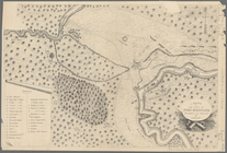
Position de l'armée Américain…
note:
Scale
approximately 1:70,000 (W 73°53ʹ29ʺ--W
Blanchard's map of Wisconsin …
note:
Scale
1:1,267,200. 20 miles to 1 inch (W
Indian Territory
note:
Scale
1:760,320. 12 miles to 1 inch (W 100
Territory of Dakota
note:
Scale
1:1,140,480. 18 miles to 1 inch (W
Railroad map of Wisconsin
note:
Scale
1:760,320. 1 inch = 12 miles (W
Indian Territory
note:
Scale
. 1:760,320. 12 miles to the inch
State of Wisconsin
note:
Scale
1:760,320. 12 miles to 1 inch (W 92°54
Indian Territory
note:
Scale
. 1:760,320. 12 miles to the inch
Map of Indian Territory
note:
Scale
approximately 1:1,500,000 (W 100°02ʹ--W
Territory of Wyoming
note:
Scale
1:950,400. 15 miles to 1 inch (W 111
Map of northwest Texas and th…
note:
Scale
approximately 1:31,000; thirty five miles
Map of the state of Texas [an…
note:
Scale
approximately 1:3,900,000. (W 104°--W 94°/N
Parts of Ohio & Pennsylvania …
note:
Scale
approximately 1:2,000,000 (W 85°--W 78°/N 43
Ohio
note:
Scale
approximately 1:335,000 (W 84°50ʹ--W 80°35
A sketch of the operations of…
note:
Scale
approximately 1:128,700 (W 74°24ʹ--W 73°44
Map of New York City and of M…
note:
Scale
approximately 1:25,344 (W 74°02ʹ51ʺ--W
Plan of the Battle of Long Is…
note:
Scale
approximately 1:15,840 (W 74°01ʹ17ʺ--W
A plan of New York Island, pa…
note:
Scale
approximately 1:85,000 (W 74°07ʹ40ʺ--W
A topographical map of the no…
note:
Scale
approximately 1:21,000 (W 73°59'57"--W
Battle of Long Island: from S…
note:
Scale
approximately 1:125,000 (W 74°03ʹ58ʺ--W
R.L. Polk & Co's map of the c…
note:
Scale
1:14,400. 1200 feet = 1 inch (W
State of Nebraska : 1879
note:
Scale
1:950,400. 15 miles to 1 inch (W
Preliminary geological map of…
note:
Scale
not given (W 95°46ʹ--W 89°59ʹ/N 40°36
m
New map of the city of Philad…
note:
Scale
approximately 1:21,000 (W 75°14ʹ00ʺ--W
Indexed map of Pittsburgh and…
note:
Scale
not given (W 80°03ʹ18ʺ--W 79°53ʹ38ʺ/N
Rand, McNally & Co.'s Missouri
note:
Scale
approximately 1:1,000,000 (W 96°00ʹ--W 88°30
m
Rand, McNally & Co.'s map sho…
note:
Scale
1:506,880. 8 miles to 1 inch (W 77°32
Map of St. Joseph, Mo. and vi…
note:
Scale
1:9,600. 800 feet to an inch (W
1
2
3
4
5
6
7
8
9
10
Previous
Next
1
2
3
4
5
6
7
8
9
10
Previous
Next