Click to visit the main New York Public Library Homepage
The New York Public Library
Digital Collections
About Digital Collections
Browse
Search only public domain materials
Items
Collections
Divisions
Home
Search
Browse
About
Search only public domain materials
Items
Collections
Divisions
Digital Collections
Using Images
Using Data
Search
Filtered keyword search
Show filters
Hide filters
Show Only Public Domain
topic
Real property
10889
Fire insurance
5305
Cities & towns
5007
City planning
1087
Social conditions
942
More
Less
name
Sanborn Map Company
5108
G.W. Bromley & Co
2551
New York (N.Y.). City Planning Commission
980
M.I.T. Press
942
Bromley, George Washington
857
More
Less
collection
Atlases of New York City
11592
Atlases of the United States
3839
Maps of North America
3345
Maps of New York City and State
2057
Lawrence H. Slaughter Collection of English maps, charts, globes, books and atlases
1248
More
Less
place
New York (State)
13151
New York
4862
New York (N.Y.)
3351
Manhattan (New York, N.Y.)
2239
Brooklyn (New York, N.Y.)
1212
More
Less
genre
Maps
23265
Atlases
3762
Topographic maps
1050
Cadastral maps
594
Nautical charts
394
More
Less
publisher
Sanborn Map Company
5145
G.W. Bromley & Co
2371
MIT Press
942
E. Belcher Hyde
807
K.u.K. Militargeographisches Institut
774
More
Less
division
x
Map Division
type
cartographic
22270
still image
1222
text
755
Date Range
to
Looking for one of these collections?
Atlases of New York City
11,722 items
Atlases of the United States
3,868 items
Maps of North America
3,345 items
Maps of New York City and State
2,059 items
Lawrence H. Slaughter Collection of English maps, charts, globes, books and atlases
1,252 items
Spezialkarte der Osterreichisch-Ungarischen Monarchie
774 items
23,798 results found for:
x
map
Filtering on:
x
Division
: Map Division
Sort by:
Relevance
Title
Date created
Date digitized
Sequence
Results 21751 - 21800
… College Point. [
Map
… College Point. [
Map
… Flushing. [
Map
bounded
Mt. Washington and vicinity: …
note:
Mapping
the Nation (NEH grant, 2015-2018)…
Petersburg and Five Forks : f…
note:
Mapping
the Nation (NEH grant, 2015-2018)…
A draught of Port Royal Harbo…
note:
…: http://nla.gov.au/nla.
map
-rm410.
Plan von den Operationen der …
note:
NYPL
Map
Div. copy has accession no
Sketch J showing the progress…
note:
Mapping
the Nation (NEH grant, 2015-2018).
Savannah River, reconnaissanc…
note:
Mapping
the Nation (NEH grant, 2015-2018)…
Map
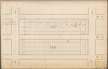
of Drainage System on Lower Part
Key:
Map
of the City of New York
Central Park Planning
Map
No. 3: Bounded
New Hampshire & Vermont
note:
Appears in:
Maps
of Maine, New Hampshire
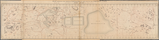
Map
Showing the Original Topography
Key continued:
Map
of the City of New York
m
Piscataqua Harbour, Portsmout…
note:
Mapping
the Nation (NEH grant, 2015-2018)…
Plan of Boston and its vicini…
note:
Mapping
the Nation (NEH grant, 2015-2018)…
Preliminary chart of Bull's B…
note:
Mapping
the Nation (NEH grant, 2015-2018)…
Preliminary sketch of Chincot…
note:
Mapping
the Nation (NEH grant, 2015-2018)…
Key continued:
Map
of the City of New York
Mineral territory tributary t…
note:
Mapping
the Nation (NEH grant, 2015-2018)…
Tidal currents of Nantucket S…
note:
Mapping
the Nation (NEH grant, 2015-2018)…
Key continued:
Map
of the City of New York
Preliminary chart of St. Mark…
note:
Mapping
the Nation (NEH grant, 2015-2018)…
Sketch of Frying-Pan Shoals a…
note:
Mapping
the Nation (NEH grant, 2015-2018)…
Sketch of The Narrows in Bost…
note:
Includes two ancillary
maps
: Tower Rock
Beaufort River, S.C. : from B…
note:
Mapping
the Nation (NEH grant, 2015-2018)…
Cumberland coal region: shewi…
note:
S.H. Sweet ; sections of
map
by Prof
A plan of Bahia del Espiritu …
note:
Publication details from
Maps
K.Top
Eleventh l. h. district
note:
Mapping
the Nation (NEH grant, 2015-2018)…
New-York City, County, and vi…
collection:
Maps
of New York City and State
Preliminary chart of Ossabaw …
note:
Mapping
the Nation (NEH grant, 2015-2018)…
Map
of Erie County, New York
note:
by Samuel Geil, author of
maps
of Niagara
Map
of the New York wilderness
note:
Inset: [
Map
of the Northeastern states
Geological
map
of the district between Portage
note:
… of the printed
maps
of Michigan
m
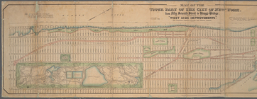
Map
of the upper part of the City of New
note:
…"The figures on the
map
representing
m
Watson's new
map
of New York and adjacent
m
Map
of Tioga County, New York
note:
County
map
, showing cities and towns
McClung's
map
of Minnesota …
note:
… catalog of the
Map
m
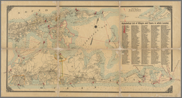
Map
of Long Island
note:
…"Balliet & Volk,
map
engravers, 27 So
m
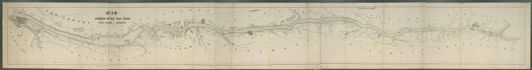
Map
of the Hudson River Rail Road from New
note:
… to Early
Maps
of the Middle
Hooker's new pocket plan of t…
note:
… to Early
Maps
of the Middle
A
map
of the most inhabited part of Virginia
note:
Described in: Fry & Jefferson
map
of Virginia
m
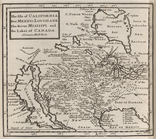
The isle of California, New M…
note:
… to Early
Maps
of the Middle
Traveller's
map
of Michigan, Illinois, Indiana
note:
… catalog of the
Map
m
Colton's new
map
of Long Island
note:
Mapping
the Nation (NEH grant, 2015-2018)…
m
New
map
of the state of New York
note:
Also includes inset: [
Map
of the New York
Sketch
map
of the City of Newyork
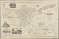
Map
of Westminster Park of the Thousand
note:
Includes inset
map
of: [Thousand Islands
Map
of Greene Co., N.Y. and portions
note:
Mapping
the Nation (NEH grant, 2015-2018)…
1
2
…
85
86
87
88
89
90
91
92
…
95
96
Previous
Next
1
2
…
85
86
87
88
89
90
91
92
…
95
96
Previous
Next