Click to visit the main New York Public Library Homepage
The New York Public Library
Digital Collections
About Digital Collections
Browse
Search only public domain materials
Items
Collections
Divisions
Home
Search
Browse
About
Search only public domain materials
Items
Collections
Divisions
Digital Collections
Using Images
Using Data
Search
Filtered keyword search
Show filters
Hide filters
Show Only Public Domain
topic
Administrative and political divisions
425
Railroads
345
History
244
Landowners
224
Real property
218
More
Less
name
United States Coast Survey
129
Bache, A. D. (Alexander Dallas), 1806-1867
93
Burr, David H., 1803-1875
70
Bien, Julius, 1826-1909
62
Geological Survey (U.S.)
59
More
Less
collection
Maps of North America
1835
Maps of New York City and State
570
Lawrence H. Slaughter Collection of English maps, charts, globes, books and atlases
326
Atlases of the United States
64
Atlases of New York City
59
More
Less
place
New York (State)
541
United States
402
North America
215
New York (N.Y.)
198
Virginia
188
More
Less
genre
Maps
2973
Topographic maps
163
Cadastral maps
155
Nautical charts
104
Atlases
59
More
Less
publisher
publisher not identified
200
s.n
58
U.S. Coast Survey
51
U.S. Coast Survey Office
37
Topographical Bureau
34
More
Less
division
x
Map Division
type
cartographic
2970
still image
52
text
47
Date Range
to
Looking for this collection?
Maps of North America
3,345 items
2,976 results found for:
x
Reliefs
Filtering on:
x
Division
: Map Division
Sort by:
Relevance
Title
Date created
Date digitized
Sequence
Results 2251 - 2300
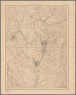
Albany and vicinity
note:
Relief
shown by contours.
Johnson's Delaware and Maryla…
abstract:
Relief
shown by hachures. Shows railroads
Reconnaissance of entrance & …
abstract:
Relief
shown by hachures. Depths shown
General map of explorations a…
abstract:
….
Relief
shown by hachures
New Jersey (Sussex County) Fr…
note:
Relief
shown by contours and spot heights.
Reconnaissance of Grenville H…
abstract:
Relief
shown by hachures; depths shown
Map showing the distribution …
abstract:
Relief
shown by hachures. Inset: Aleutian
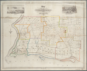
Map of the town of Niagara
note:
Relief
shown by hachures and rock drawings.
m
Map of the Department of Dako…
note:
Relief
shown by hachures.
A general chart of all the co…
abstract:
Relief
shown by hachures and land forms
m
Colton's railroad & township …
note:
Relief
represented by hachures.
Bird's-eye view of the mounta…
note:
Relief
shown pictorially and by stop
m
The Matthews-Northrup up-to-d…
abstract:
Relief
shown by hachures. Prime meridians
Map of Broome County, New York
note:
Relief
shown by hachures.
m
Map of the counties of Bergen…
note:
Relief
shown by hachures.
Washington Territory
abstract:
…, D.C.
Relief
shown
Chicago harbor
abstract:
Relief
shown by soundings. "Senate Ex. Doc
m
Higginson's map of New York a…
abstract:
….
Relief
shown by hachures
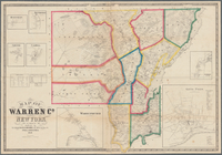
Map of Warren Co., New York
note:
Relief
shown by hachures.
m
Hardee's geographical, histor…
abstract:
… features.
Relief
shown
m
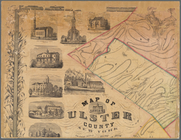
Map of Ulster County, New York
note:
Relief
shown by hachures.
Cram's sectional map of Dakot…
abstract:
Relief
shown by hachures. Prime meridians
Map of the state of Missouri
abstract:
Relief
shown by hachures. Prime meridian
Johnson's North Carolina and …
abstract:
…, and harbor in inset.
Relief
Preliminary survey of Turtle …
note:
Relief
shown by hachures. Depths shown
Map of the City of San Franci…
abstract:
…, etc.
Relief
shown
Carte des possessions Russes
abstract:
Shows Alaska.
Relief
shown by shading
Map of military reservation o…
abstract:
Relief
shown by hachures. "Proposed
Preliminary chart of Plymouth…
abstract:
Relief
shown by soundings. Includes sailing
m
Map of Tioga County, New York…
note:
Relief
shown by hachures.
Colton's new illustrated & em…
note:
Relief
shown by hachures and spot heights.
Antietam
abstract:
Relief
shown by hachures. "General
m
Map of the city of Boston and…
note:
Relief
shown by hachures.
Johnson's Oregon and Washingt…
abstract:
….
Relief
shown by hachures
To the Right Honourable Willi…
abstract:
… Rivers.
Relief
shown
m
Lloyd's official map of the s…
abstract:
….
Relief
shown by hachures
Map of Bar Harbor, Maine, 1896
note:
Relief
shown by contours.
Phelps's national map of the …
note:
Relief
shown by hachures.
A map of the confluence of th…
note:
Relief
shown by hachures.
Territory of Wyoming
abstract:
… physical features.
Relief
m
Map of the Denver & Rio Grand…
abstract:
… of Arizona.
Relief
shown
Montana, Helena special map
abstract:
Relief
shown by contours and spot heights
Johnson's Nebraska, Dakota, I…
abstract:
…] National Park.
Relief
shown
The Cornplanters Reserve, Ven…
abstract:
….
Relief
shown by shading
Colton's new map of the state…
abstract:
Relief
shown by hachures. Depths shown
A topographical map of the st…
note:
Relief
shown by hachures.
m
State of California
abstract:
… reservations, etc.
Relief
shown
San Francisco Peninsula
abstract:
Shows drainage, railroads, etc.
Relief
shown
Asher & Adams' new map of the…
note:
Relief
shown by hachures and spot heights.
Omaha and vicinity : Nebraska…
note:
Relief
shown by contours and spot heights.
1
2
3
4
5
6
7
8
9
10
11
12
Previous
Next
1
2
3
4
5
6
7
8
9
10
11
12
Previous
Next